OMG OG
What an amazing play to cap off the greatest comeback ever in an NBA finals game. The Knicks are one game away from their first NBA championship since 1973. I’ve definitely caught Knicks fever and have been having a good time following them through the playoffs. One more!
2026 - let's go
Happy new year! At the moment I don’t feel like I have anything too insightful to say about the coming year so I’ll keep this brief.
I’ve got some solid momentum going with my guitar practice and my budding yoga practice so I’m hoping to continue those things throughout 2026. In addition to that stuff I’m planning on riding my bike a lot, reading a bunch of good books, and going on some fun camping trips. I’m going to try my best to keep this blog updated, which is easier now that I’m not really spending time on social media. No promises, but I’m going to try to consistently get some interesting things posted on here throughout the year.
Here’s to 2026 – let’s make it a good one.
Guitar plugins - a journey (part 2)
I’ve always thought some day I’d upgrade to a high-end modeling platform, be it Helix or Fractal or NeuralDSP or whatever is the best fit for me at the time I’m ready to take the plunge. Yeah, I also have a dream of owning a nice tube amp and might do that some day as well. But only playing at home (at lower volumes) and wanting the flexibility of messing around with a variety of tones, it just makes more sense to go the modeling route. You can easily spend between $1,000-$2,000+ for a good tube amp. You can get a high-end modeling solution, which includes a bunch of different amps and effects, for less than that, which seems like a good deal. So I was really excited to be able to test out Helix Native and see and see if this might be a way to get into this higher-tier of the modeling world without spending a bunch of money.
Unfortunately, after a few hours of testing I didn’t find that it sounded that much better than my GTX100. In fact I don’t think it sounded as full and present as the GTX100, even though I was using the same speaker. I think the main issue here is that Helix Native allows you to tweak a lot of options, including, and perhaps, most importantly, the cabinet simulation, which involves different microphone types and placements and even entirely different (third-party) impulse responses (IRs). I think it’s safe to say that Helix is better than the GTX100, if you know how to tweak it. But, I don’t. So I was a bit disappointed with how it sounded, at least with minimal changes out of the box.
This was kind of a big moment for me. I love my GTX100 and think the Fender “cleans” it provides sound amazing. But I always thought the overdriven stuff wasn’t that great and had the notion that the high-end modeling solutions, like Helix, would be a million times better. But after hearing what Helix Native had to offer, I realized that the GTX100 is actually pretty damn good.
Again, I’m sure this is just my lack of experience and skill in dialing in Helix tones. It’s fun to tweak and mess around with this stuff, but, at least for me, that fun only continues up to a point. After a while I just want decent tones that make my playing sound better (or at least allow me to have more fun since my playing isn’t that great).
Around this time Universal Audio had also put nearly all of its plugins on sale so I got the trial versions of a few of their amps and started experimenting with those. Right away I found the presets and, really, just the the amp plugins in general sounded better than Helix Native – at least with minimal tweaking. I felt that the Ruby (Vox AC30) and Lion (Marshall Plexi) also sounded a lot better than the comparable amps in the GTX100. And I liked the interface/user experience with the UA plugins a lot more than Helix Native; there were things to tweak, but it wasn’t overwhelming. UA’s sale made it a lot cheaper to buy these than Helix Native so I did that and had a lot of fun messing around with them.
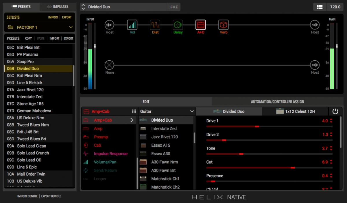 Helix Native plugin interface
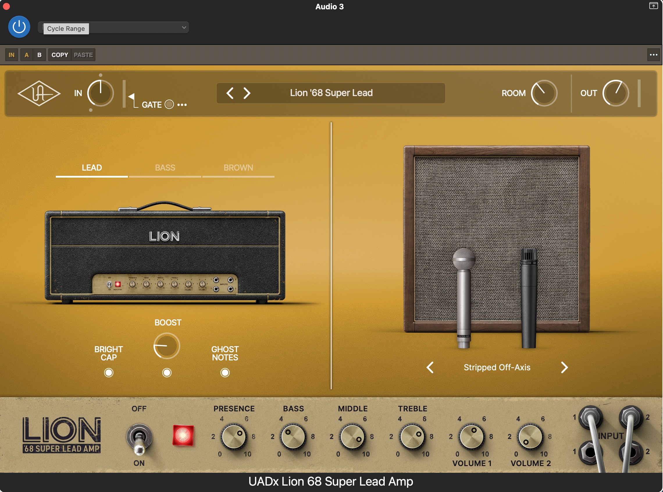 Universal Audio Lion plugin interface
I should note that nearly all of this stuff is quite subjective. Arguing about guitar tone and even UX preferences is a bit like arguing about favorite foods or colors. Some people prefer different things, which is what makes life interesting, right? There is no single right answer here; you like what you like and that’s cool.
A week or so after I bought the aforementioned guitar amp plugins from Universal Audio they dropped a brand new plugin called “Paradise Guitar Studio,” which, as Murphy’s Law would have it, includes all of the guitar amps I had just bought. :( However, it also includes the new “Enigma” amp, which I didn’t have. (The Enigma amp model is really three different types of Dumble amplifiers.) It packages everything up nicely in a single interface and also includes a bunch of effects like various distortion and modulation pedals as well as reverb, equalizers, compressors, etc. And, it allows you to mix and match all the various speaker cabinets and microphones between the different amp models. Prior to the Paradise Guitar Studio plugin you couldn’t use cabinets from the Marshall amp with the Deluxe Reverb amp, for instance. Universal Audio was also really cool in that they recognized people who had purchased the individual components (like me!) and offered a really good discount on this new plugin so I ended up buying it right away and have been using it almost exclusively since I did.
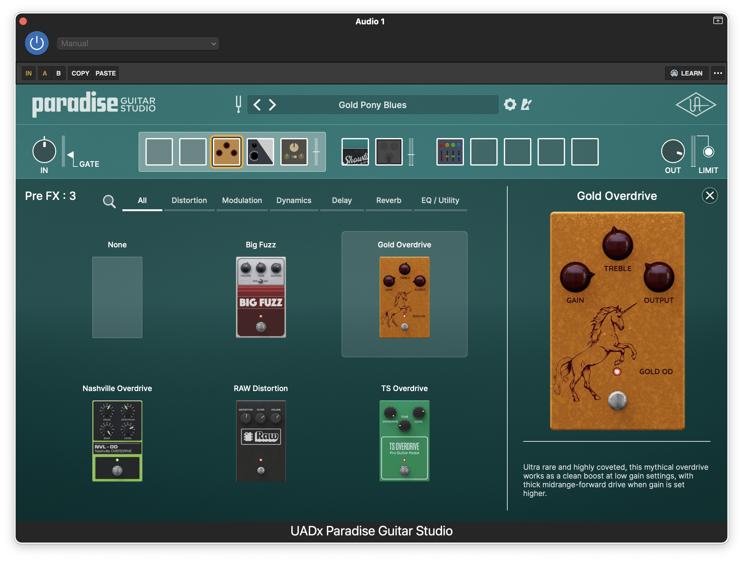 Universal Audio Paradise Guitar Studio pre-FX interface
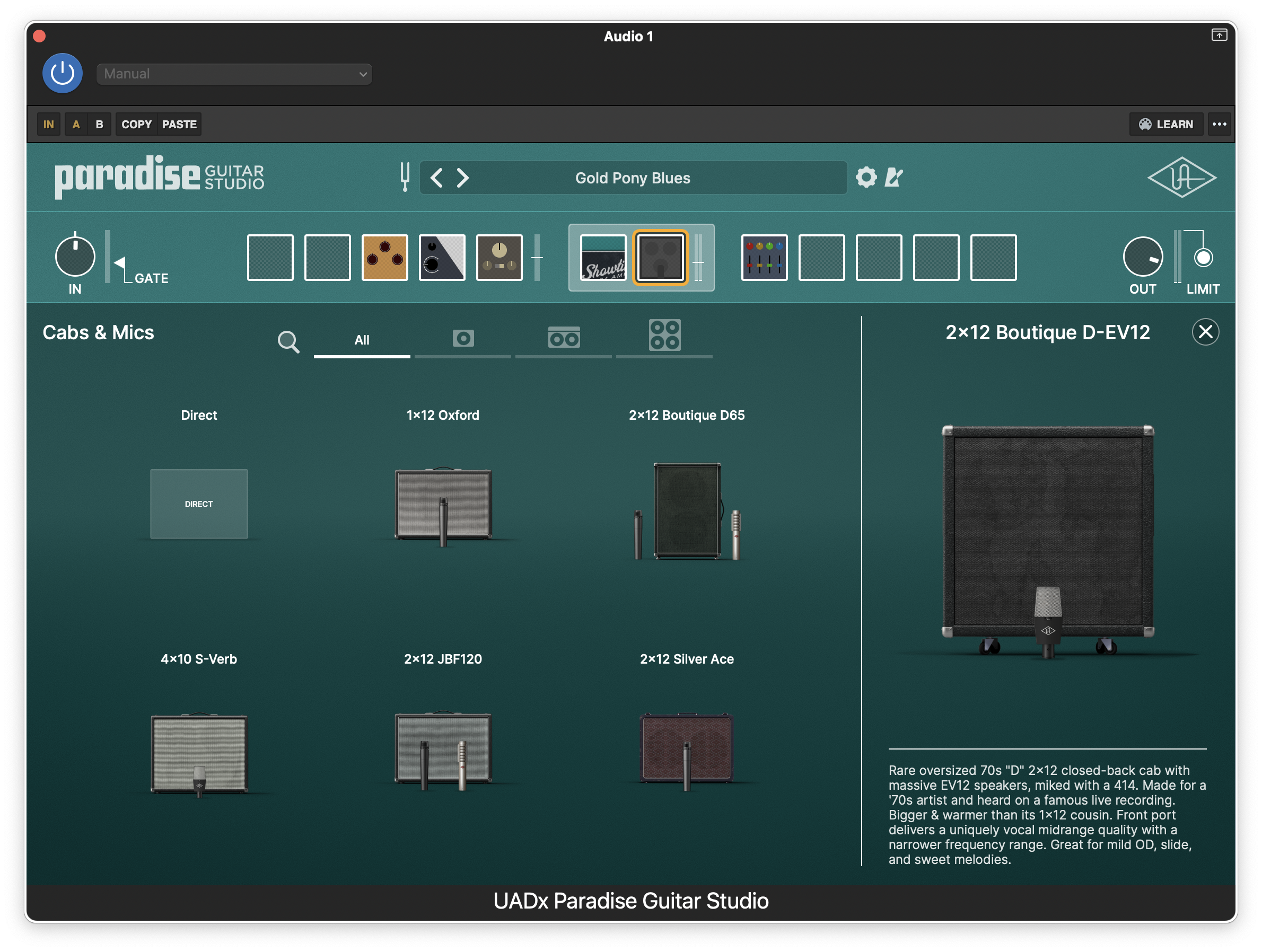 Universal Audio Paradise Guitar Studio speaker/cabinet interface
So that’s where I’m at now. I’m hoping to spend some time dialing in some new presets and learning more about the Enigma amp options after the holidays. There are always new things to learn about and explore when it comes to this stuff, but I think for now I’m really happy with all of the different options I have at the moment re: amps and effects.
Guitar plugins - a journey (part 1)
A couple months ago I knew nothing about guitar plugins – how they worked or really even that they existed. I had a vague notion I could use GarageBand on my laptop to simulate a guitar amp as well as various effects, but because I’ve always used “physical” amps, I had never really experimented with that feature.
A few weeks ago, though, I came across a Black Friday sale for Helix Native, which allows you to use all the amps and effects the Helix hardware devices include. But, as I learned, with Helix Native you don’t need to buy any Helix hardware; you can just use your computer and whatever DAW you have (e.g., GarageBand in my case) and load Helix Native as a plugin. There are a lot of different companies that provide plugins, which, like Helix Native, can either be used with a DAW or in some cases can be used as a standalone app if you don’t want to record and just want to play.
Backing up a little…. I currently have a two amps: a Fender Mustang GTX100 and a Positive Grid Spark 2, both of which are modeling amps. In the past I’ve connected both of these to my laptop via USB and have messed around with recording some simple practice stuff using GarageBand, which has has worked well enough for my basic purposes. Whenever I did this always used the tone from the amp rather than any of the GarageBand amps or effects.
After I saw that Helix Native was on sale and learned a little more about guitar plugins, I got more curious about the GarageBand amps and effects and took another look at those. However, when I was using either of my amps as the audio interface (i.e., the connection from my guitar to my computer) it didn’t work that well due to the delay between when I plucked a string and actually heard it. This delay only seemed to happen when using my speakers, though; I couldn’t detect it when using headphones, which seems weird so perhaps I had something misconfigured. I was also having a hard time figuring out the best way to get an uncolored signal into GarageBand from either amp. I figured out some workarounds, but they weren’t great. Lastly, I’m not terribly crazy about using headphones all the time so using my amps for the audio interface to my computer was kind of a dead-end.
This led me to start looking into a proper audio interface and since it was the holiday season almost all of the various options were on sale. I settled on a Volt 1 from Universal Audio. I found this worked much better than the interfaces from my amps and I wasn’t getting any delay, even with speakers. I also discovered – and this was really the key to this whole experiment – that using the output from the audio interface I could use my GTX100 as a speaker. Specifically if I used the return of the effects loop on the GTX100 it would essentially act as a powered speaker and none of the “color” from the amp would be involved. So the amp, effects, and cabinet simulation from whatever I’m using in the plugin would be piped out through the 12-inch speaker in my GTX100. Normally if you use a guitar amp as your speaker the cabinet/microphone simulation from the plugin would be layered on top of the characteristics of the physical amp and speaker cabinet. It might still sound great, but wouldn’t be a true representation of the simulation the plugin is creating. Using the GTX100’s effect loop, though, avoided all of this.
I think most people use powered monitors (aka speakers) if they don’t want to use headphones with whatever modeling solution they’re using. This definitely works and provides some cool stereo sounds. However, if you’re used to playing with a guitar amp and like the sound and feel that provides, it’s definitely different than playing through stereo monitors. Both can be good, it just depends on what you’re looking for. Anyway, I tested this all out using the included GarageBand plugins and it worked really well. I then downloaded the Helix Native trial and started messing around with that.
A short rooting guide
Let’s say there’s a game or sporting event going on and you don’t really have a dog in the fight, so to speak. Your favorite team or player is nowhere to be found yet you want to be involved and cheer for someone. But, you’re just not sure who deserves your support. Here’s a short guide to help you figure out who to get behind.
Before we start please take a quick pause and realize how lucky you are to be blessed with this situation. You’re able to sit back and enjoy a contest without any emotional involvement. You won’t experience the heartbreak of watching the team you’ve supported your whole life lose in a crushing defeat. Sure, you also won’t experience the thrill of watching them win a playoff game or championship. But let’s be honest – the chances of that happening are probably quite small, which is why you’re here trying to figure out who to cheer for during the World Series or NFL wildcard game.
Let’s get started. Go through the short questions below, pick your team, and then enjoy the game!
- Is one of the teams or players from Canada? If so, go for them.
- Does one of the teams or players have any association or history supporting Donald Trump? If so, pick the other team.
- If neither team or player is from Candada or there’s a tie between supporting/not supporting Trump (and his ilk), then ask if either is from California? If so, pick them as California is pretty great.
- If none of the above applies or is helpful go to the tie-breaker, which is simply to pick the team with the best colors and/or uniform design.
I applied this formula during this year’s MLB playoffs and settled on the Toronto Blue Jays, which I’m very happy with since they’ve advanced to the World Series. And even though they’re playing a team based in California, the choice was easy to continue supporting them. I mean, look at that logo!
![]() Swoon
Swoon
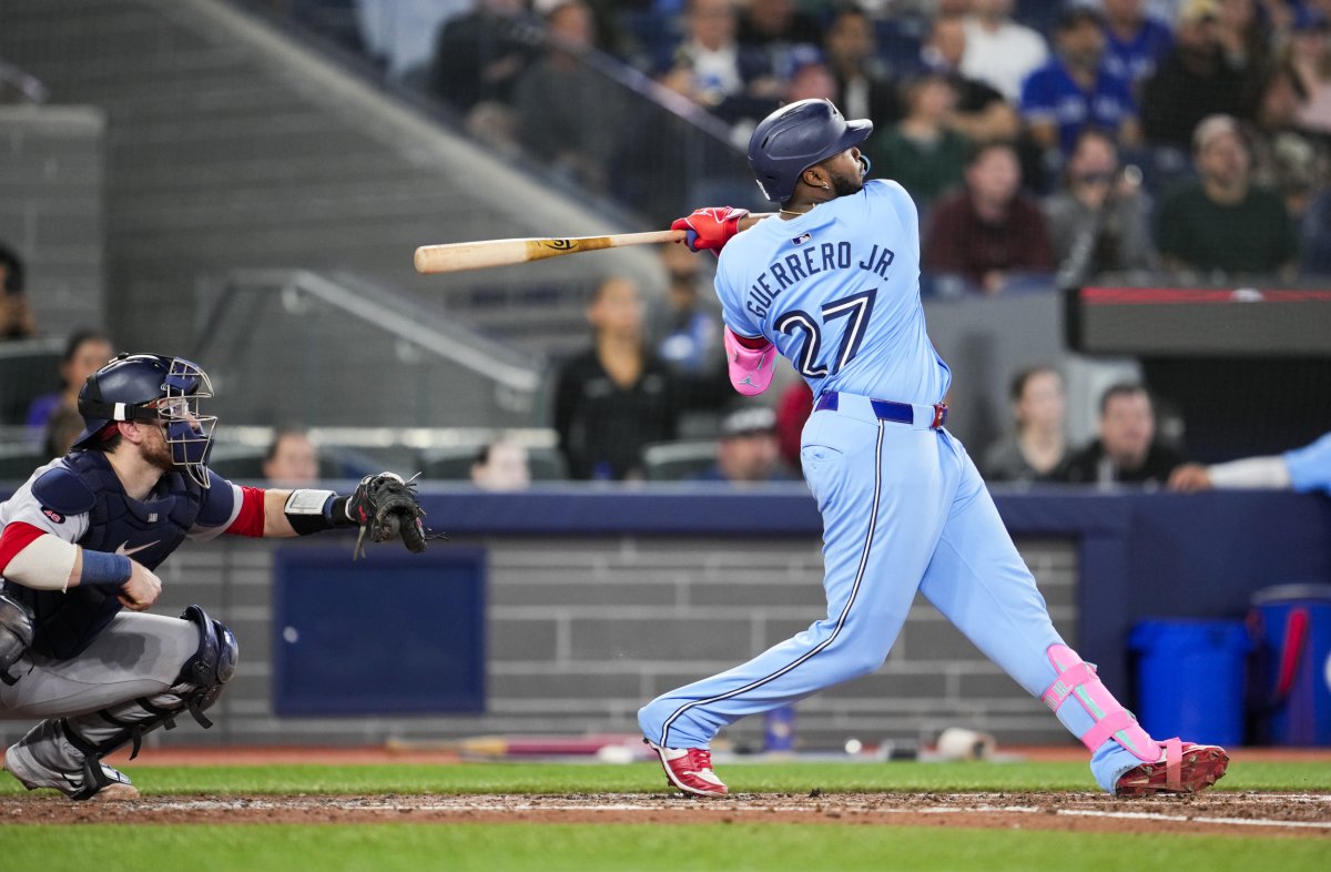 Powder Blue?! Now you’re just showing off.
 Never forget